
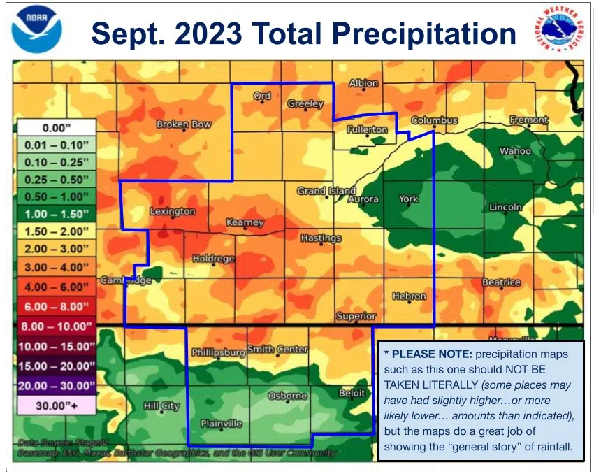
ELWOOD — If it had not been for the evening of Thursday, Sept. 21, sites in Gosper County would have only seen around an inch of rain during the month, instead over half of the entire month’s total fell that evening.
The National Weather Service – Hastings released the September 2023 total precipitation map and areas of the west of the Tri-Cities heavily benefited from the rainfall produced by the Sept. 21 thunderstorms.
An observer two miles northwest of Elwood reported 5.29 inches of rain during the entire month of September. Of note, the same observer reported 4.10 inches fell on Sept. 21, or 77 percent of the entire month’s total.
The heaviest swath of rain during the evening fell from northeastern Gosper County into northwestern Phelps County. One Phelps Co. resident reported 5.25 inches on Sept. 21.
The western portion and central portion of the NWS Hastings warning area saw the heaviest precipitation amounts.
- Elwood: 5.29 inches
- Shickley: 4.79 inches
- Kearney Airport: 4.73 inches
- Lexington: 4.41 inches
- Axtell: 4.24 inches
- Kenesaw: 4.24 inches
- Blue Hill: 4.13 inches
The areas with the lowest precipitation totals were the far east and Kansas counties in the NWS Hastings area. A few areas include:
- Osborne, Kan.,: 0.04 inches
- Hunter, Kan.,: 0.23 inches
- Waco: 0.74 inches
The Tri-Cities Airports reported:
- Grand Island: 1.55 inches, 78 percent of normal, 5th driest on record, but wettest since 2018
- Hastings: 2.96 inches, 114 percent of normal, 43rd wettest on record, wettest since 2018
- Kearney: 2.89 inches, 257 percent of normal, 11th wettest on record, wettest since 2004
For reference normal precipitation amounts across the NWS Hastings area range from 1.70 to 2.50 inches, generally the lowest in the west and highest in the east. Last month bucked this trend.
The continued dry conditions to the east of the Tri-Cities have led to the continued exceptional drought, D4, conditions across several counties. Total coverage of this most severe drought condition remains at 14.02 percent.
Hall County is seeing a gradient of exceptional drought, severe drought, D3 and severe drought, D2, conditions from east to west, respectively. Adams County is under similar conditions.
There was some slight mitigation to the west of the Tri-Cities, while Buffalo County is roughly split between severe drought conditions and moderate drought, D1, conditions.
“Increasing 30 to 60-day deficits along with support from SPIs at various time scales and the NDMC’s short-term drought blend, a 1-category degradation was made to northeastern Kansas and southeastern Nebraska,” the U.S. Drought Monitor stated in their Thursday update.


