National Weather Service - Hastings, Courtesy
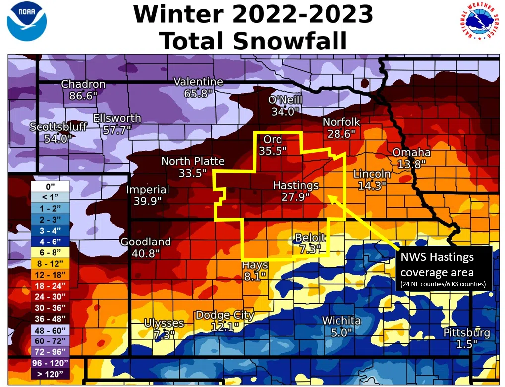
HASTINGS — While the first snow of the season has already fallen across much of the Tri-City area, the National Weather Service – Hastings looks back on last year’s snow fall amounts across their warning area.
“One of the most notable things about last winter was just how ‘normal’ snow totals were across most of our coverage area, with most places totaling within five inches either side of their official 30-year normal amount,” NWS Hastings stated.
“There were exceptions to this prevailing ‘normality’, with some places, including Holdrege and Kearney picking up at least 10 inches more than normal, and other places, such as York, Greeley and Beloit Kan., falling at least 8-14 inches short of normal,” NWS Hastings noted.
The first measurable snow of the season fell Nov. 14, 2022, as mainly the extreme southeast edges of our area, mainly Osborne, Mitchell, Jewell and Thayer counties received anywhere from a dusting up to 2.0 inches.
The last measurable snow of the season fell March 31, 2023, as mainly the extreme northwest fringes of our area, mainly Valley and Sherman counties, picked up a light dusting up to around one-half inch.
As is often the case, most of the seasonal snow at any given location fell during two to four separate snow events. Here is a rundown of the main snow events of the 2022-23 season provided by NWS Hastings.
- Jan. 3-4: Although this event mainly impacted locations north-northwest of our coverage area, much of especially Dawson, Sherman, Valley counties received a widespread 4-7 inches, including 7 inches in Ord.
- Jan. 18-19 featured a widespread 6-16 inches across most of our Nebraska coverage area, including 15.5 inches in Ord and 14 inches eight miles south of Elwood. In places such as Ord and Grand Island, this storm alone constituted around 40 percent of the snow for the entire season.
- Jan. 21-22: Although not a major event, mainly our Kansas coverage area saw a widespread 4-7 inches, including a localized higher total of 9.0 inches at Logan. The 5.5 inches at Beloit constituted 75 percent of Beloit’s snow for the entire season.
- Feb. 15-16 featured 5-10 inches for many places particularly between roughly Highway 6 and the Kansas border, including a localized higher total of 11 inches in Beaver City.
- March 25-26 brought a fairly narrow swath of heavy snow, mainly 5-9 inches to portions of primarily the following Nebraska counties: Buffalo, Hall, Howard, Merrick, Nance, Polk, including 9.0 inches in Kearney and 8.5 inches in Osceola.
Within the 24 south central Nebraska counties, per official NWS observers:
- The highest 2022-23 seasonal snow totals were 36.0 inches in Holdrege, Phelps County and 35.5 inches in Ord, Valley County.
- The lowest official seasonal totals included only 11.7 inches in Hubbell, Thayer County and 13.2 inches near York, York County.
In the Nebraska Tri Cities, from NWS observers near Grand Island and Kearney airports, Hastings snow measured at NWS office:
- Grand Island: 26.6 inches, 1.1 inches below normal. This was the first very-near-normal seasonal snow total in Grand Island since the 2014-2015 season and was a notable 14.5 inches more than the prior season, only 12.1 inches in 2021-22.
- Hastings: 27.9 inches 0.7 inches below normal. This was the first very-near-normal seasonal snow total in Hastings since the 2019-2020 season and was a notable 18.8 inches more than the prior season, only 9.1 inches in 2021-22.
- Kearney: 32.7 inches, 10.9 inches above normal). This tied for the 31st-snowiest season on record and was a notable 24.4 inches more than the prior season, only 8.3 inches in 2021-22.