RAVENNA — When it comes to photography…and life in general, I live by the motto that luck is simply preparation and opportunity coming together. Friday, April 26 demonstrated to me why it always pays to be prepared.
I hadn’t even planned to chase on Friday. After my outing in northwest Kansas on Thursday, I was planning on using Friday as a stand down day to prepare for what looked to be the main event on Saturday, April 27.
Severe weather and the possibility of tornadoes, some strong, was in the forecast for the eastern part of Nebraska and into Iowa. In hindsight I should have put more stock in Friday’s event than Thursdays.
But storm chasing doesn’t pay the bills and I had already taken most of Thursday to chase so I knew I would be at work on Friday. Working in a radio station has its benefits, especially when it comes to how weather warnings are disseminated to the public.
I wasn’t paying attention to the weather at all, but was trying to wrap up several 2024 election candidate articles before the weekend. But it was just before noon that a severe thunderstorm warning was paged out over the air, which I heard on Y102 first.
I stopped what I was doing to see what I was missing and the radar showed a severe warned thunderstorm that had developed over Ravenna in northern Buffalo County.
I noted that the storm was already beginning to take on the pendant shape that is common to supercells. With an upper level area of low pressure tracking over central Nebraska, I knew it wasn’t out of the question for storms to form right off the surface low that had also tracked into the area.
The fact that the storm was already exhibiting the general shape of a supercell set off my mental alarm that I should get in viewing range of this storm quickly. Between the storm being in our news coverage area and that I am a local weather spotter, it was a simple decision to head north.
I had already cleared my cameras of the previous day’s photos and had everything packed away in case I needed to run in a moment’s notice, that comes from covering breaking news events for the past five years.
I headed east out of Kearney as fast as I could and as soon as I could get a better view of the thunderstorm, there were signs that this one might be special. The first thing I noticed was the overshooting top above the anvil cloud.
An overshooting top represents a very strong updraft and hence a higher potential for severe weather with that storm. The updraft is forcing air parcels above a stable layer of the atmosphere.
Before I turned north on Ravenna Road, the National Weather Service – Hastings issued a tornado warning due to the strengthening mid-level rotation the cell was beginning to exhibit.
My decision to take off when I did was vindicated, I chalked my hunch up to the past five years I have spent storm chasing and the pattern recognition that comes with enough experience.
I drove north as fast as I could, while the general structure of the storm began to come into view through the myriad of low level clouds. I could start to make out the mesocyclone and some flaking line convection.
I arrived in Ravenna around 12:25 p.m. and the bridge over the railroad tracks gave me a better vantage for a moment. I could clearly see a more compact area of rotation that I felt could have been a tornado cyclone, but I wouldn’t know for sure until I got my eyes on the base.
On the north side of town I passed one Ravenna Volunteer Fire Department grass rig and was following a second as they headed north outside of town.
I have a great deal of respect for these volunteers who not only answer our fire and emergency calls, but also serve as weather spotters for their local communities.
As I cleared Ravenna, the tension began to rise as it was clear something was going on under the storm’s base, the area of concentrated rotation was just too compact.
As though I was a part of some movie thriller scene, I couldn’t see the base at first because of a homestead’s windbreak. As I rounded a slight bend on Highway 68 I could finally see the entire northern horizon.
There it was.
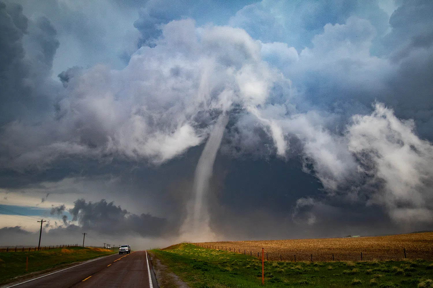
Descending out of a mass of swirling white clouds was a narrow rope tornado, stark white in brilliant contrast against the darker clouds behind it.
For a moment I thought the tornado may be dissipating as many tornadoes take on a narrow rope like appearance just before they expire.
But as I continued north, the slender twister kept planted over the farmland of Sherman County. I knew I had to get as close as I could before it vanished.
I passed a semi and cattle pot on the side of the highway, the driver much wiser than me to observe the tornado from a distance.
As I got closer I could make out more details of the tornado, the fact that it was a nearly translucent inner funnel, surrounded near its base by a cylinder of condensation.
I finally closed to within less than a quarter of a mile of the tornado after I could finally see its base which had been blocked by the terrain. Thinking this was close enough I pulled the car off to the side of the road and grabbed my camera.
Opening the door I was greeted by a howling wind from behind that was feeding into the tornado. The base of the tornado began to turn a light brown as it picked up dust from the field it was moving over.
As I watched the tornado shift to the west, nearer to the highway, I distinctly felt my lizard brain screaming at me to get away from the swirling mass.
This was by far the closest I have ever been to a tornado but I made my decision to hold my ground. The rational part of my mind knew this tornado was on the weaker end and might not have much longer to live.
The instinct proved right, when the twister began to cross the highway, it seemed to lose all strength and the funnel faded quickly. It was a captivating and eerie sight to witness as the dust fell away but a ghost of a funnel could be seen for just a few moments more.
It took me a moment to realize that this was the 11th tornado I have witnessed since I began chasing in 2018.
After I got back in the car, I suddenly realized how much my hands were shaking. The rush of adrenaline had been intense and I realized it only after I was trying to work out what to do first.
The first thing to do was to make a report to NWS Hastings, other spotters were out but I didn’t want to make the assumption that someone else had called.
Thanks to the adrenaline, I probably sounded like I was coming off a manic episode when I was explaining the details of what I had witnessed to the meteorologist.
The second call I made was to Alex, “Hammer” Hammke, who was doing live weather updates for Hits 106.
Having worked in the past for a newspaper, I had usually only relayed reports to the NWS but being able to provide the ground truth in the moment made me feel like I was doing my part to help keep people safe.
After doing my due diligence, I kept heading north to keep up with the storm. At a junction I turned east, heading toward Rockville.
As I passed through the area where the storm’s precipitation core had passed, I got to experience another phenomenon for the first time – hail fog.
Hail fog is an unusual type of fog that forms shortly after a heavy hailstorm.
As the hail accumulates on the ground, it cools the air just above the ground to the dew point, resulting in fog. The fog forms when winds are light, and it is usually quite patchy and shallow.
Driving over hail is not a particularly enjoyable experience, it feels like there are a million tiny marbles under your tires and that their grip could let go at any moment.
I didn’t know it at the moment due to the trees and terrain, but a second tornado had touched down and passed through the eastern side of Rockville.
As I began to head southeast on Highway 58, I suddenly became aware of damage that occurred in the area of Rockville Avenue.
This was also a first, in my five years of chasing I had yet to run across tornado damage.
As I drove up Rockville Ave. I noticed large broken tree limbs, parts of a metal building that were in pieces and blown into the tree line.
Eventually I could go no farther because a large tree had been blown down across the roadway.
I decided that my hobby as a storm chaser had ended and my job as a local reporter began. I parked the car and began walking around the area to document the damage, both for news reporting and to share with the NWS.
I’ve seen photos of tornado damage before, but to witness it first hand was bizarre. I looked around and here was a piece of metal setting hanging over a power line as though it was laundry out to dry, over here was a power line that had been snapped at the base, but thanks to the tension of the wires, was now hanging among the tree limbs.
My heart dropped when I saw a home on the edge of Rockville had suffered damage to the edges of its roof, with the bare trusses showing in places. I chase to see tornadoes, but I never want to see them damage people’s property and lives.
I made additional calls to the NWS and Hits 106 regarding the damage and then made ready to head back to the office and file an article about what had occurred.
The storm had outpaced me at this point but it was not finished, dropping a large wedge tornado that caused damage to the community of Elba.
In fact, the Ravenna tornado I had witnessed turned out to be only the first that would be a part of an outbreak that would occur across the state, especially eastern Nebraska.
A supercell thunderstorm would spare Lincoln a direct impact, but would begin producing several tornadoes, some of which were violent. The first crossed I-80 and was well documented by the metro area and storm chasers – the footage lighting up TV screens and social media.
As it neared the Omaha metro area, the storm produced a large wedge tornado, its evil black structure looking more at home in the 1999 Oklahoma tornado outbreak than 2024. This tornado tore through Elkhorn and severely damaged many homes.
At the time of writing, NWS Omaha was still conducting their damage survey of the tornadoes that impacted their area.
To see the impact and destruction this outbreak caused was shocking and left somewhat of a bitter taste in my mouth. There is part of me that wished I could have witnessed more of what was a historic tornado outbreak in my home state.
But on further reflection, I think I should be content that the tornado I was able to lay eyes on caused no damage as it wandered over rural farmland. I can also say I was able to see the first tornado that touched down as a part of the April 26 outbreak.
It feels good knowing that I was able to add yet another tornado sighting to my tally but the effects of the outbreak is yet another sobering reminder about the power of Mother Nature.
For all of our best laid plans, when the winds come a howlin’ – we learn we can’t control it, we can only ride it out the best we can.