
HASTINGS — The change in drought conditions across central Nebraska and the wider state has been drastic from late June in 2023 to 2024.
The substantial drought conditions across the region can be traced back to the historically dry year of 2022, which was comparable to the drought of 2012.
Across the National Weather Service – Hastings 30-county coverage area, 2022 was a notably dry year with most places falling between five to 12 inches short of 30 years normal.
Some locations had to dig back further in the record books to find a drier year. For example, Hastings had its driest year in 56 years, since 1966.
“For many official long-term NWS stations, 2022 ranked between a top 10 and top 15 driest years on record,” NWS Hastings stated.
Going back, the preceding year 2021 was also notably dry a majority of the time but the final totals for the year were somewhat skewed by a near record to record-wettest March for some areas.
However, 2022 did not have any particularly wet months, with most locations averaging somewhere between modestly drier than normal and far drier than normal. The overall driest months were January, February, August, October and November.
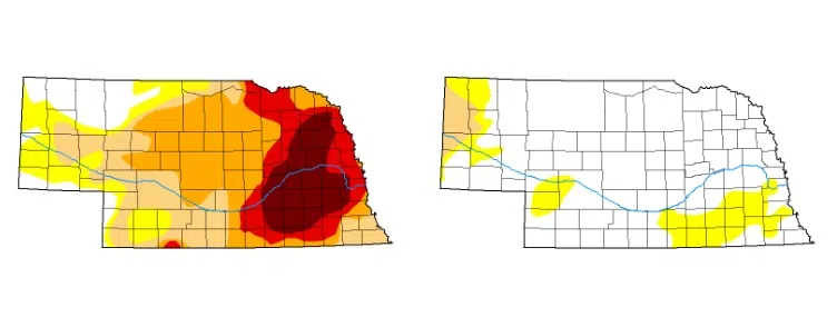
In early 2023, 100 percent of Nebraska was under some type of drought condition.
By late June 2023, a pocket of exceptional drought conditions had set in across eastern Nebraska, while the Tri-Cities and surrounding area were under a mix of extreme, severe and moderate drought conditions.
“Extreme drought conditions have settled on a cluster of counties in southeast Nebraska while a severe drought plagues other counties in the region,” the Nebraska Farm Bureau stated in early 2024.
There would be a shift in the overall weather pattern heading into 2024, one that would bring more beneficial rainfall to the area.
“May 2024 marked the 10th consecutive May with above average precipitation in Nebraska with a statewide average of 4.15″, 0.65″ above the long-term average,” according to the Nebraska State Climate Office.
“This year it was sections of central and eastern Nebraska picking up significant rainfall and seeing drought improvement or eradication while much of the Panhandle was drier than average and saw some degradation on the U.S. Drought Monitor,” stated the Nebraska State Climate Office.
It was noted that areas along Highway 30 saw 10 inches in a 24-hour period between May 20 and May 21.
“For many areas in the central U.S., including much of Nebraska, May 2024 was one filled with severe storms. A big culprit was persistent troughs in the western U.S. that ejected out into the Northern Plains region, which helped set the stage for severe thunderstorms to the south and east of the base of the mean center of the trough,” the Nebraska State Climate Office stated.
All of the rain had beneficial effects, mitigating the ongoing drought conditions.
Now by late June 2024, there is only a swath of Abnormally Dry conditions in Adams, Webster, Clay, Nuckolls. Fillmore and Thayer counties in central Nebraska.
The only Moderate Drought conditions are found in the extreme west of the Panhandle. Otherwise nearly all other counties are free of drought conditions.
“The High Plains region experienced a mixture of both deteriorating and improving drought conditions last week, which has predominantly been the case over at least the last month. High pressure over the eastern U.S. and an active storm track across the northern tier of the lower 48 states have been able to funnel moisture northward over the past few weeks, but precipitation has been hit-and-miss from week to week,” the U.S. Drought Monitor stated.


