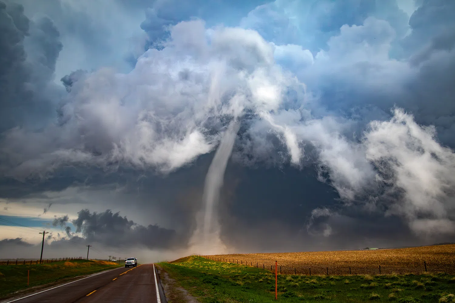
An EF-1 tornado near the end of its life north of Ravenna on April 26, it was the first to occur as part of a tornado outbreak in Nebraska, (Brian Neben, Central Nebraska Today)
HASTINGS — Want to avoid being fooled by harmless scud clouds and an actual tornado this spring?
The National Weather Service – Hastings SKYWARN storm spotter training classes are the place to become more informed about a myriad of severe weather topics
“Relaying accurate information effectively is critical during severe weather. Therefore, we feel that it is important to attend spotter training in person to optimize this process,” NWS Hastings stated.
The start times for the classes are at 6:30 p.m. and each training lasts around two hours. They are free and open to the public with ages 10 years and older likely to get the most out of the trainings.
The classes are scheduled in collaboration with local emergency management officials. Residents may attend a class at any location, offered by any NWS office, regardless of where they live.
Class times across central Nebraska includes:
- March 3, Valley County, Arcadia, Fire Station, 110 Bridge St.
- March 4, Hall County, Grand Island, Hall County Commissioner Center, 1210 N. Road
- March 5, Furnas County, Oxford, Fire Station, 314 Odell St.
- March 10, York County, Bradshaw, Fire Station, 416 Lincoln St.
- March 12, Clay County, Clay Center, Clay County Fairgrounds, 101 N. Martin
- March 12, Dawson County, Lexington, Annex Building, 200 W. 7th St.
- March 13, Greeley County, Wolbach, Fire Station, 304 Center Ave, 7 p.m.
- March 17, Hamiliton County, Aurora, Fire Station, 906 13th St.
- March 18, Phelps County, Holdrege, Location to be decided
- March 19, Nuckolls County, Nelson, Fire Station, 570 Main St.
- March 20, Harlan County, Alma, Johnson Community Center, 509 W. Main St.
- March 31, Sherman County, Litchfield, Winter Building, 204 N. Main St.
- April 7, Adams County, Hastings, Emergency Operations Center, 2965 S. Baltimore St.
- April 7, Howard County, St. Libory, Fire/EMS Station, 336 US 281
- April 10, Fillmore County, Milligan, 514 N. St.
- April 16, Kearney County, Minden, Fire Station, 325 N. Colorado Ave.
- April 16, Webster County, Guide Rock, Fire Station 538 E. State St.
- April 22, Gosper County, Elwood, Fire Station, 507 Ripley St.
- April 24, Buffalo County, Ravenna, 224 Alba Ave.
“Virtually every community has some form of spotter network. Often, local fire and police personnel are trained to observe and report severe weather, partly due to their extensive radio communication and 24-hour operations,” NWS Hastings states.
“Spotters provide this real-time ground-truth of local conditions — such as hail size, wind speed, tornado development, and local damage — to help warn the public. Even as new technology allows the National Weather Service to issue warnings with greater lead time, spotters will always serve as a critical link between radar indications of severe weather and what’s happening on the ground,” per NWS Hastings.
Providing an accurate report is crucial so NWS offices can provide timely reports that have credibility in the minds of residents.
The most important factors in a report include what the spotter is seeing, where they saw it and when. Other details including duration, direction of travel and damage are also important.
Events that NWS offices need to know about include tornadoes, wall clouds, funnel clouds, hail of all sizes, wind speeds, damage and flooding.
When reporting a tornado, wall cloud or funnel cloud, report if there is visible rotation.
Reporting hail sizes come with some caveats, when making a report don’t reference the size of the hail to items that can change in size, such as marbles. Report hail in reference to coins, sports balls or citrus fruits. Make sure to report the time, size, duration and location of hail.
Hail up to one inch, or quarter sized, is considered severe.
Reporting wind speeds can be tricky and often people report the damage wind has done. As a note, wind speeds 58 mph or greater are considered severe. Again, make sure to report time, speed, duration and location.
For flash flooding, report if there is water flowing or standing across a roadway, if roads are closed or washed out, if creeks or streams have overflown their banks, floating cars, flooding on the first floor of buildings and debris flows.
Social media, including Twitter and Facebook, have become an easy way for the public to quickly report what they are seeing to their local NWS office.
SKYWARN
SKYWARN is a program sponsored by the National Weather Service. The program is made up of thousands of volunteers who attend regular training and then scan the skies of their communities identifying and reporting critical storm information.
These volunteers, sometimes organized under the SKYWARN banner in the U.S., are typically trained by NWS forecasters to be the eyes and ears of both the warning forecasters and the local public safety networks.