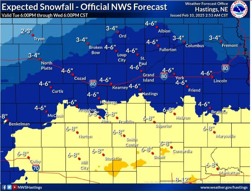
Projected snow fall totals through Wednesday, Feb. 12, (NWS Hastings, Courtesy)
HASTINGS — A strong winter system will impact the region Tuesday through Wednesday which will bring several inches of snow, with the heavier amounts favoring areas south of the Tri-Cities.
A Winter Storm Watch at the moment has been issued for all the Nebraska counties along the Nebraska-Kanas state line in the National Weather Service – Hastings’ warning area.
The watch is in effect from 6 p.m. Tuesday, Feb. 11 through 6 p.m. Wednesday, Feb. 12.
This winter system is being influenced by an upper-level trough of low pressure that will dig into the central United States with a sharp temperature gradient setting up over central Kansas.
Snow amounts in the watch area could range from 6-8 inches, while areas north, including the Tri-Cities, could see around 4-6 inches. NWS Hastings notes there could be a sharp divide between the lower amounts to the north and higher amounts to the south.
This will be an all-snow event with no threat of freezing rain or ice, snow will be on the drier and fluffier side. Blowing and drifting snow will not be a major concern, but gusts up to 20 mph could still cause minor drifting and visibility issues.
With the passage of a cold front, temperatures will be 15 to 20 degrees colder between Monday and Tuesday. This cold air looks to remain in place through Thursday. Overnight wind chills looks to be below zero degrees throughout the rest of the week.
The coldest night of the week looks to be Wednesday evening with wind chill values in the minus 10 to minus 20-degree range, bordering on a Cold Weather Advisory.