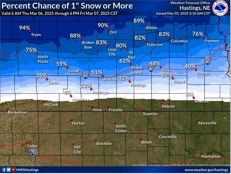
Chances of more than one inch of snow by Friday, March 7, (NWS Hastings, Courtesy)
HASTINGS — A High Wind Warning will come to an end at 12 p.m. on Wednesday, March 5 after 18 hours of strong to severe winds. Looking at the late week, more substantial snow accumulation looks likely.
Winds will gradually weaken but still will remain strong throughout the day Wednesday. There may be clouds upstream of the local area, but partly sunny skies can be expected this afternoon as the departing area of low pressure that caused the winds will track farther east.
The next upper level low pressure system will begin to cross the intermountain west on Thursday and gradually begin to influence the local area. A cold front will rapidly cross the area Thursday night into Friday morning.
This front will be the focus for the majority of precipitation and there is increasing confidence there will be at least some minor accumulation of snowfall north of Interstate 80. If the current forecast of 2-3 inches remains consistent, a Winter Weather Advisory may become necessary.
Cooler air will linger behind the cold front on Friday before a notable warm up begins over the coming weekend as a large area of high pressure begins to build aloft. This ridge should keep the local area dry through at least Tuesday.
However, with the warmer weather, fire weather concerns will reenter the picture on both Monday and Tuesday.