NORTH PLATTE — After an extremely slow start to the storm season in the Central Plains, I was able to spot a rather unique phenomena – landspout tornadoes. I have a particular history with these types of twisters.
I had been itching to chase since late April when my choice of target was off and instead of a supercell in southwest Nebraska, storms fired in the Sandhills and a storm produced several tornadoes, including a large wedge.
After that the pattern just…shut off. I knew from the start of the season that 2025 had to be quieter than the active 2024, but having to sit and wait nearly a month for the next chance to chase was starting to drive me a bit insane.
I joked that I was going to have to just start chasing rain shafts, but even those had been in short supply through early May.
Relief was due on Wednesday, May 14 as the upper-air pattern finally turned more active, with a large-scale trough of low pressure digging into central Plains.
A Slight Risk for severe weather had been issued across much of Nebraska, with a five percent chance for tornadoes. Storms were expected to fire along a surface boundary that would set up in western Nebraska.
Given the wind profile, it was clear that with northern extent, storms would favor more of a linear line but discrete development was possible in southwestern Nebraska.
After watching the surface boundary set up throughout the day, it was clear to see via the visible weather satellite views, I watched as storms began to fire in the north due to daytime heating reaching its peak.
By the time I saw a small area of showers pop up north of McCook, I made the decision to hit the road and see what these storms could do.
I watched on radar as the showers developed into a sub-severe thunderstorm. I could tell the storm was not strengthening in a hurry, but it wasn’t dying either. I held out hope that this storm could strengthen later in the day as the better upper level forcing arrived and the low-level jet kicked in.
After I had caught up with the storm near Maywood, it was an easy task keeping up with it, the storm motion was only around 15 mph to the north. I could tell the storm had a high cloud base and this isn’t a great sign if you want to see a supercell-driven tornado.
But there is another kind of tornado that doesn’t seem to care how high the cloud deck is.
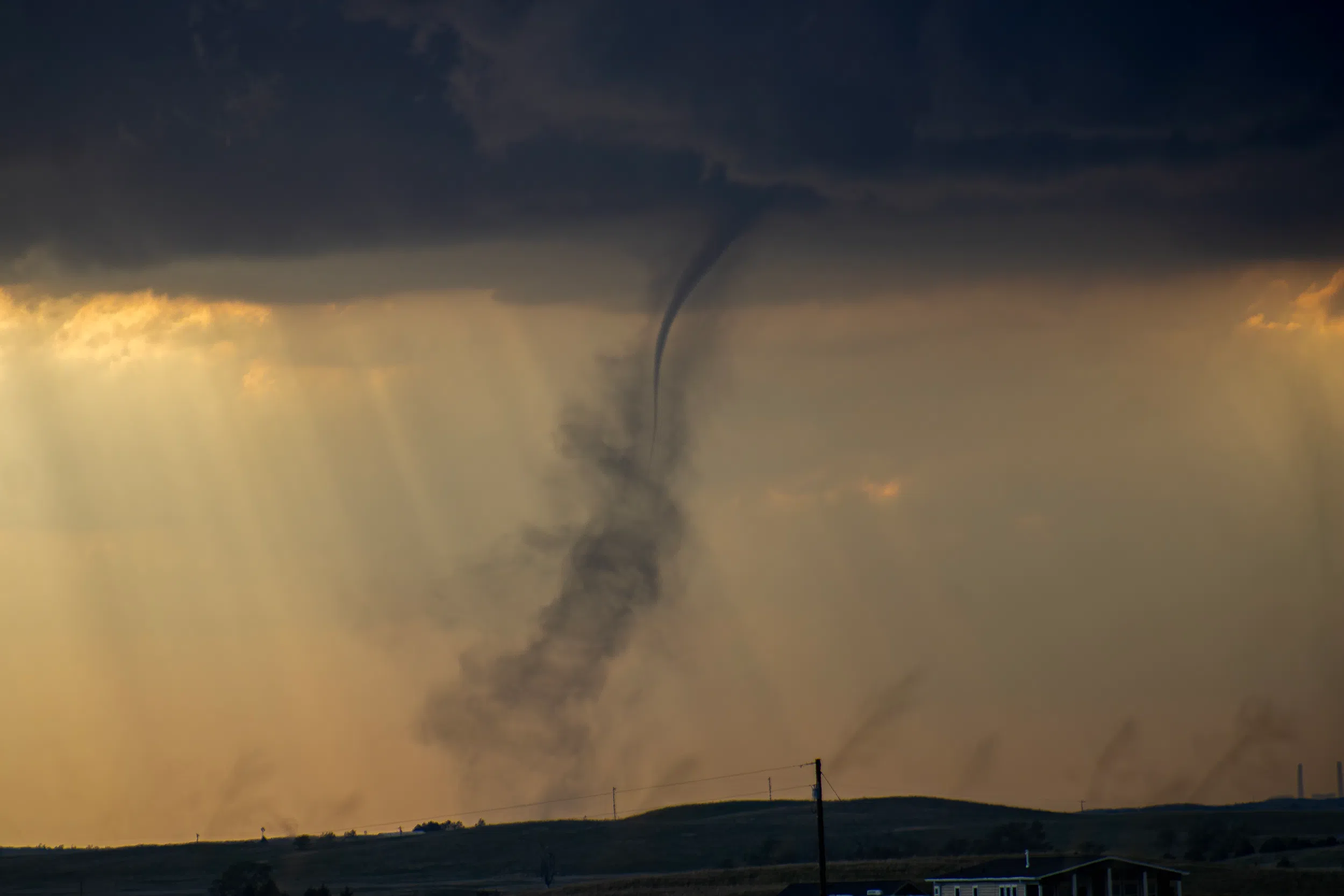
The storm was passing over the community of Wellfleet when I noticed something descending out of a cloud base to my northwest. I struggled to see through the hills for a few minutes but finally the terrain leveled out a bit so I could see what was going on.
I was looking at a tornado, but its appearance immediately identified it as a landspout.
A landspout tornado is unique because they are not associated with the mesocyclone of a supercell.
Landspouts share a strong resemblance and development process to that of waterspouts, usually taking the form of a translucent and highly laminar helical tube.
Landspouts occur when a storm or updraft passes over a boundary and the preexisting vorticity is pulled upward into the vertical into a strong vortex. Landspouts can also occur due to interactions from outflow boundaries, as they can occasionally cause enhanced convergence and vorticity at the surface.
These generally are smaller and weaker than supercell tornadoes, but can still cause damage.
The first tornado I ever witnessed was a landspout tornado when I was 10-years-old.
My mom was driving us home on one of those hot and humid days in the early summer and it was clear that it would be a stormy evening. Earlier we had been standing outside and noted with some apprehension that the wind had gone slack and then suddenly began blowing out of the opposite direction.
On the drive back home, I remember looking back over my shoulder to see what I thought at first was smoke rising near the Platte River. I assumed at first that lightning had struck on Jeffrey Island and started a fire.
When I looked back a few minutes later, I realized I was not looking at smoke, but a twisting column of dust that was taller than the Canaday Steam Plant in the area.
I will never forget the words I said urgently to my mother, “Mom, there is something black and swirling back there.”
I don’t think mom fully believed me until she looked in the rear view mirror and then gunned the engine.
The 1996 movie “Twister” wasn’t doing my imagination any favors because I had visions of this howling tornado hunting us down on the road.
All of my siblings were scared to death by the time we got back home, sure that the tornado would be on our heels at any moment. But we were astonished when there wasn’t anything mentioned on the local television station about tornadoes.
Having learned all I can about tornadoes, I shouldn’t have been surprised there wasn’t anything mentioned on TV. Because of this lower depth, smaller size, and weaker intensity, landspouts are rarely detected by Doppler weather radar.
Seeing that tornado at a young age had an immense influence on me and was likely one of the reasons that pushed me into storm chasing when I got older. I also remember telling myself I never wanted to be scared of a tornado ever again.
I had no need to be afraid looking at the landspout near Wellfleet as I was over 10 miles away.
Forming in relation to mesocyclones and under updrafts, a landspout generally lasts for less than 15 minutes; however, they can persist substantially longer, and produce damage.
Due to their formation along a boundary, if a storm tracks along it, there can be clusters of landspouts, which is what happened on May 14. Not long after the first one dissipated, a second one which was more well defined formed.
The third one I saw was the longest lasting of the evening, and was nearly stationary. Gazing through my camera, It was amazing to see a funnel as thin as a needle and with a helical cloud of dust underneath it. The setting sun was shining through the clouds near the surface providing an excellent backdrop for the ongoing twister.
For a moment the funnel fully condensed but was still as thin as a rope. I also marveled at what appeared to be smaller areas of vorticity on either side of the tornado, visible due to the dusty conditions. They seemed like smaller dust devils moving toward the landspout.
It took me a moment at the time to realize that this was the first landspout tornado I had seen since I was a child. I think 10-year-old me would have been proud to see the photographs that I was able to capture.
By the time the third landspout had dissipated, the storm complex was nearing North Platte and it was evident that the oncoming cold front would undercut the storms and our landspout-fest was over.
Even though this severe weather season has been off to a slow start, it was a confidence boost to be able to see three unique tornadoes on my first major outing.
I will still be on the hunt for a supercellular tornado, but at the moment, beggars can’t be choosers.
Editor’s Note: My name is Brian Neben and this is my seventh year as storm spotter and chaser. I write a personal column about each outing, as it helps to collect my thoughts and I have felt like people enjoy reading about my success or failures pursuing this rather niche hobby.