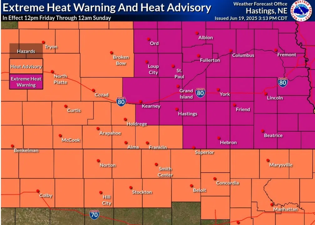
Extreme Heat Warning and Heat Advisory in effect for Friday, June 20 through Sunday, June 22, (NWS Hastings, Courtesy)
KEARNEY — An Extreme Heating Warning has been issued for parts of central Nebraska from Friday, June 20 through Sunday, June 22. An Extreme Heat Watch will be in place through Sunday itself.
The National Weather Service – Hastings has issued the warning to go into effect from 12 p.m. Friday to 12 a.m. Sunday. All other surrounding areas area in a Heat Advisory.
NWS Hastings notes this is the first dangerous heat wave of the year with the heat index reaching 105 to 110 degrees in the warning area and 100 to 105 degrees in the advisory area.
Overnight temperatures are expected to drop no lower than the mid to upper 70s overnight, providing only limited relief from the heat and allowing the daytime temperatures to warm back up quickly.
Winds will be fairly gusty by late June standards, with southerly wind gusts up to 30-45 mph. This could provide some heat relief for those outdoors, but dehydration and heat-related illnesses remain possible even in the windy conditions.
“Drink plenty of fluids, stay in an air-conditioned room, stay out of the sun, and check up on relatives and neighbors. Do not leave young children and pets in unattended vehicles. Car
interiors will reach lethal temperatures in a matter of minutes, per NWS Hastings, “Heat related illnesses increase significantly during extreme heat and high humidity events.
Upcoming near-record temperatures provided by NWS Hastings as follows:
— For Grand Island (Central Nebraska Regional Airport):
– Friday, June 20
Hottest High Temp Record: 104 in 1974 (forecast is 102)
Warmest Low Temp Record: 78 in 2022 (forecast is 74)
– Saturday, June 21
Hottest High Temp Record: 107 in 1988 (forecast is 103)
Warmest Low Temp Record: 78 in 1908 (forecast is 77)
– Sunday, June 22
Hottest High Temp Record: 102 in 1937 (forecast is 100)
Warmest Low Temp Record: 75 in 1919 (forecast is 79)
— For Hastings (Municipal Airport):
– Friday, June 20
Hottest High Temp Record: 104 in 1988/1974 (forecast is 101)
Warmest Low Temp Record: 76 in 2022 (forecast is 74)
– Saturday, June 21
Hottest High Temp Record: 105 in 1988/1936 (forecast is 102)
Warmest Low Temp Record: 75 in 2013 (forecast is 77)
– Sunday, June 22
Hottest High Temp Record: 109 in 1988 (forecast is 100)
Warmest Low Temp Record: 73 in 1988 (forecast is 78)