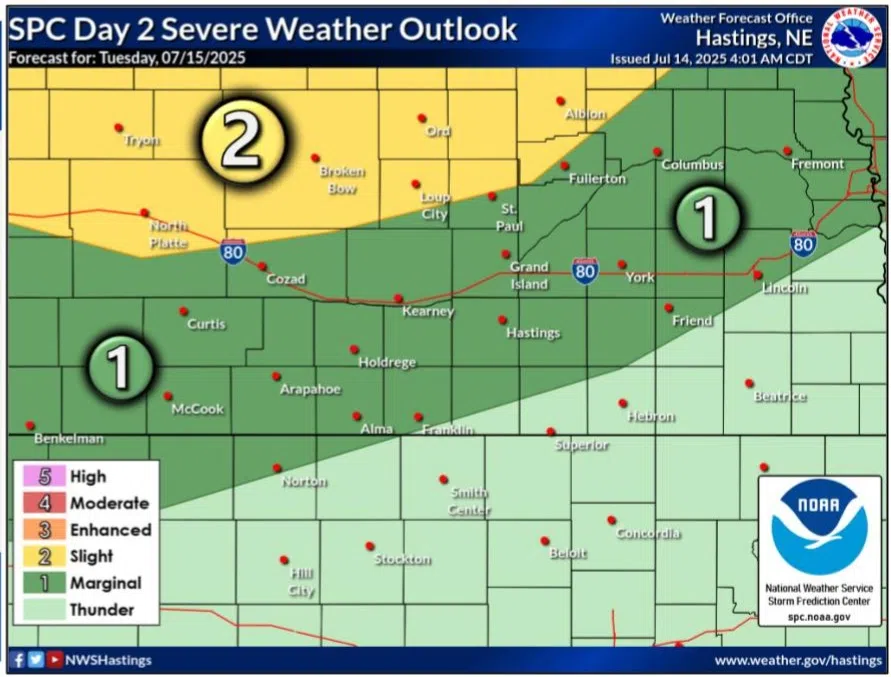
Chances for severe weather for the evening and overnight hours of Tuesday, July 15.
HASTINGS — After a warm start to the work week, there will be possible chances for strong to severe thunderstorms during the evenings of Tuesday, July 15 and Wednesday, July 16.
According to the National Weather Service – Hastings, dry conditions are forecast to continue throughout today and the daytime hours on Tuesday. Highs are forecast to be warmer than the weekend, reaching the low to mid 90s. Tuesday will also see widespread 90s.
By Tuesday, a surface low pressure area will strengthen over eastern Colorado in response to an approaching upper-level shortwave disturbance. A frontal boundary will extend northeastward through western Nebraska and central South Dakota.
Thunderstorms are expected to develop to the west of the area and evolve into a mature mesoscale convective system that will shift southeast through the evening and overnight hours, following an axis of higher instability.
How far south this activity spreads is still uncertain, but the highest chances, 50-70 percent, remain along and north of a line from Lexington to Geneva. Dye to this, most of the forecast area is included in a day two Marginal Risk, one out of five, while a Slight Risk, a two out of five, lies north of Highway 92.
Much of how Wednesday’s forecast plays out will be highly dependent upon how the Tuesday evening and overnight storms evolve. The daytime hours should be quiet, but yet another upper-level shortwave will be following on the heels of Tuesday’s system, per NWS Hastings.
“Thunderstorm activity expected to initially, primarily develop over the High Plains during the late day-evening hours, but not out of the question storms could fire further east, along a warm
front/reinforced boundary by the previous night’s outflow, which could be running through the heart of the forecast area,” per NWS Hastings.
The entire forecast area has been included in a day three Marginal Risk, per the Storm Prediction Center.
There are periodic, low confidence chances for additional precipitation for Thursday through the weekend. Cooler temperatures are expected on Thursday and Friday, before warming back up into the mid-80s and mid-90s by the time next weekend rolls around.