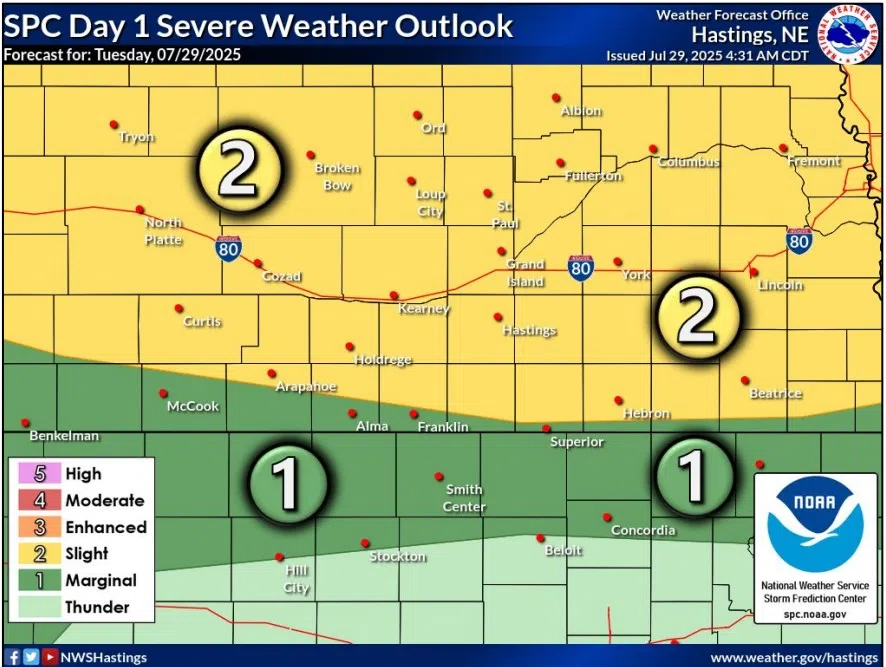
There is a Slight Risk for severe weather during the evening and overnight hours of Tuesday, July 29, (NWS Hastings, Courtesy)
HASTINGS — A Heat Advisory continues for parts of south-central Nebraska on Tuesday, July 29, while much of the area is under a Slight Risk for severe weather this evening.
According to the National Weather Service – Hastings, the Heat Advisory is in effect from 12 p.m. to 8 p.m. for areas mainly along and east of Highway 281. Areas to the west are not under the advisory, but the daytime hours will still be hot.
Due to the higher dewpoints in the advisory region, heat index values are expected to reach 100 to 108 degrees. Light winds out of the south from 5-15 mph will provide little relief.
As attention turns toward the evening and overnight hours, nearly all north and south-central Nebraska are under a Slight Risk, a two out of five, for severe weather.
Per NWS Hastings, thunderstorm development is expected to occur during the late afternoon and evening hours along a cold front that has stalled out over southwestern Nebraska. Over time, these storms are expected to cluster and form into a larger complex as it moves to the east across central Nebraska.
Initial cells to the west will be capable of producing large hail and damaging wind gusts, but as the larger storm complex takes shape, severe winds, 60-70 mph, will be possible the primary severe threat.
Locally heavy rainfall will also be possible with this line of storms, and accumulation of two to three inches will be possible through Wednesday morning.
“The strongest storms are expected to exit eastern portions of the area during the early morning hours, with stratiform rain-weak showers continuing through the rest of the overnight hours,” per NWS Hastings.
Showers will come to an end by Wednesday morning, with partly cloudy skies lingering over the area. Cooler temperatures are expected with highs only in the upper 70s and mid-80s.
Below to well below normal temperatures will persist into the weekend thanks to the northwesterly flow that will have replaced the high pressure ridging aloft.
NWS Hastings notes that the highs on Thursday and Friday will be 20-25 degrees below the forecast highs on Tuesday.