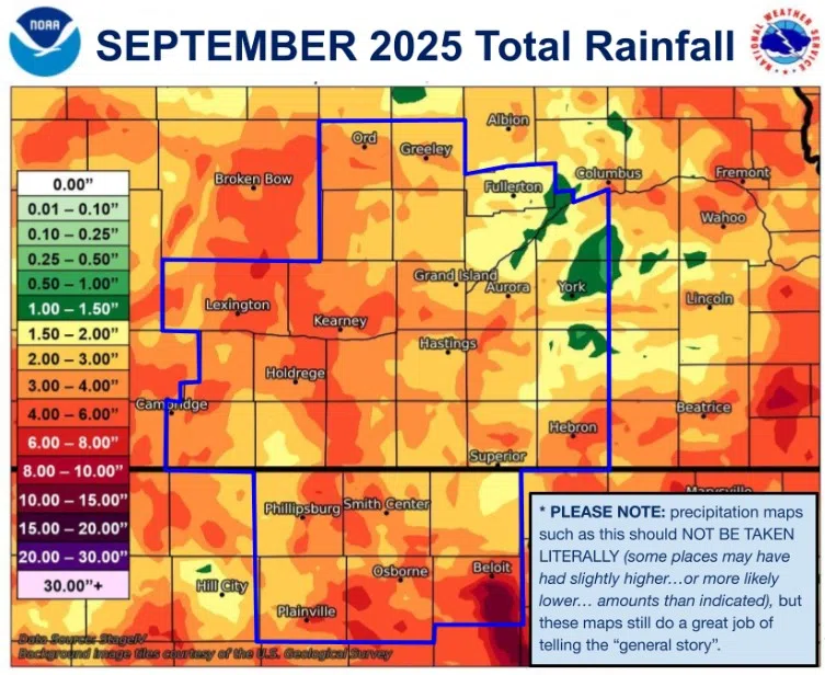
September 2025 precipitation amounts across central Nebraska, (NWS Hastings, Courtesy)
HASTINGS — Rainfall across central Nebraska was variable but it contributed to the widespread removal of drought conditions from the region.
According to the National Weather Service – Hastings, most of the region saw between 1.45 and 3.90 inches. The overall wettest were counties in Kansas, but counties in the west of the warning area also saw higher amounts. It was driest in the far east and northeast.
The areas that received the highest precipitation included Beloit, Kan., with 8.29 inches; Sumner, 7.34 inches; Tobias, 6.18 inches; Hebron, 6.17 inches and Hubbell, 5.37 inches.
The driest areas included Waco, 0.75 inches; Polk, 1.14 inches; York, 1.18 inches; Osceola, 1.39 inches; Orleans, 1.39 inches and Central City, 1.42 inches.
During the month, the Tri-Cities airports recorded the following:
- Grand Island: 1.80 inches, 90 percent of normal, wettest since 2018
- Hastings: 2.08 inches 101 percent of normal, much wetter than 2024
- Kearney: 3.46 inches, 188 percent of normal, much wetter than 2024
For reference, average September rainfall across the area usually ranges from 1.70 inches to 2.50 inches, generally lower in the west and higher in the east.
The beneficial rainfall saw nearly all drought conditions removed from central Nebraska, save for a small pocket of Abnormally dry, D0, conditions in Hamilton and York counties.
A swath of D0 conditions still reaches from the Panhandle across northern Nebraska to the northeast.
In their Sept. 30 update, the U.S. Drought Monitor stated, “Widespread moderate to heavy precipitation fell from southwest Nebraska and northwest Kansas into northern Colorado and southeast Wyoming, including some wintry precipitation at higher elevations. Rainfall amounts locally exceeded two inches in parts of northeast Colorado and adjacent parts of Nebraska and Kansas.”

Drought conditions as of Oct. 7, (U.S. Drought Monitor, Courtesy)