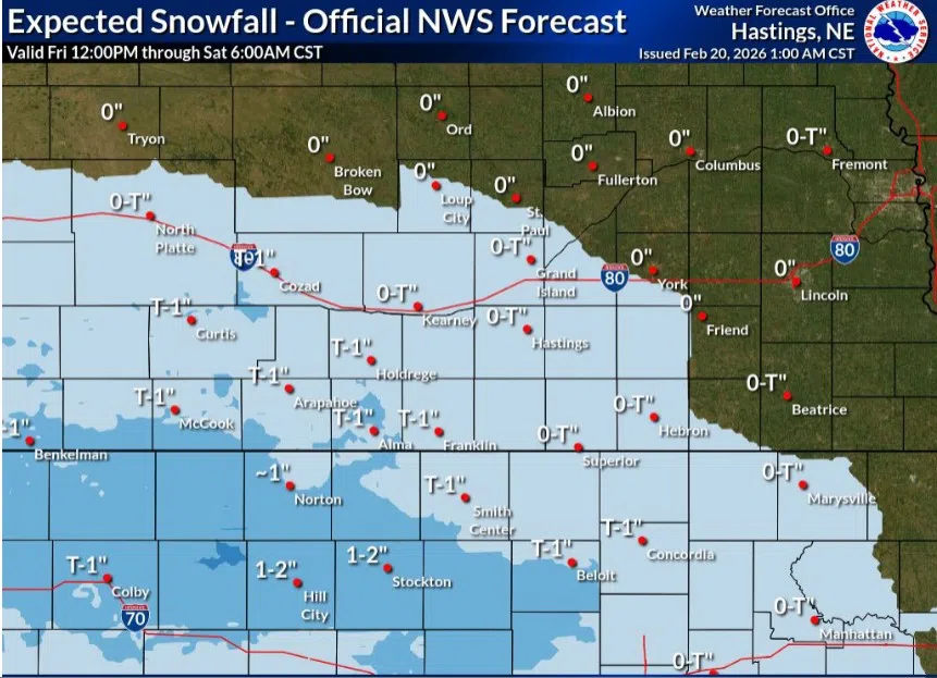
Expected snowfall throughout central Nebraska on Friday, Feb. 20, (NWS Hastings, Courtesy)
HASTINGS — After the main shot of snow on Thursday, additional chances for light snow across central Nebraska arrive this afternoon into the overnight hours of Friday, Feb. 20.
“Though the most intense snow showers this week are done and through, one smaller and less intense round of snow is expected to take shape late Friday afternoon to night across north central Kansas and some of south-central Nebraska. The best snow accumulating potential is along and south of I-80,” per the National Weather Service – Hastings.
The chances are due to another shortwave trough moving out of the southern Rockies and to lead to pressure falls that will stir up this weak system.
Light snow is expected between 4 p.m. and 10 p.m., it will spread from the southwest to the northeast, mainly south and west of the Tri-Cities.
“In total, these snow showers will be expected to remain short-lived with accumulations, more likely than not, coming to an end across the overnight to early Saturday morning hours,” per NWS Hastings.
Travel impacts are expected to be on the minor side, as winds out of the northwest at only 5-10 mph will keep blowing snow to a minimum. However, slick road conditions on uncleared or untreated roadways may still be a factor in the Friday evening and Saturday morning commutes.
“The vast majority of locations that see snow should mainly only see accumulations of a trace up to a few tenths of an inch. Otherwise, the rest of the weekend is expected to be dry with highs in the mid-20s to mid-40s and lows in the single digits and teens,” NWS Hastings stated.
The coldest temperatures will fall across areas that have a snow depth of greater than one inch. Winds will stay out of the north, gusting no higher than 15-20 mph.