BROKEN BOW — I have not chased nearly as much as I did during the wall-to-wall season that was 2024. So, when a slow-moving cold front was set to initiate thunderstorms in north central Nebraska, I was just happy to see more storms and the additional chances of rain.
While the goal is to see tornadoes each storm season, the reality is that the majority of storms do not produce tornadoes and the storm mode on Monday, June 2 would be far more favorable for heavy rain and straight-line winds.
This is due to the fact that a cold front, even a slow moving one, strongly forces the air up that is ahead of it and so the storm mode along this type of feature generally favors more linear segments, rather than discrete storms.
The storms are more outflow dominant and anyone who has seen a large self-cloud seemingly dominating the horizon should know they were likely looking at the outflow of the parent thunderstorm.
With a solid idea of what type of storms I would be seeing, I knew I would be hunting shelf cloud structure.
Temperatures reached into the 90s ahead of the front and storms began to initiate in segments along as line from North Platte to Broken Bow to Ord and farther to the northeast.
I left home around 4 p.m. and jumped up to Highway 40 with a decision on which area to target. Anywhere along the line of storms would do, but I made the decision to head north to Broken Bow where it was clear there was a stronger precipitation core.
As I headed north along Highway 21, I could start to see the edge of the cloud formations and knew I would be able to get some worthwhile pictures, I just had to get into position.
However, as soon as I arrived in Broken Bow, it was clear I was going to have to jog to the east as the edge of the precipitation core was bearing down on town. I had been stuck amid a hailstorm in Broken Bow back in 2021 when I overestimated how fast I could navigate the stop lights in town and didn’t want to repeat that experience.
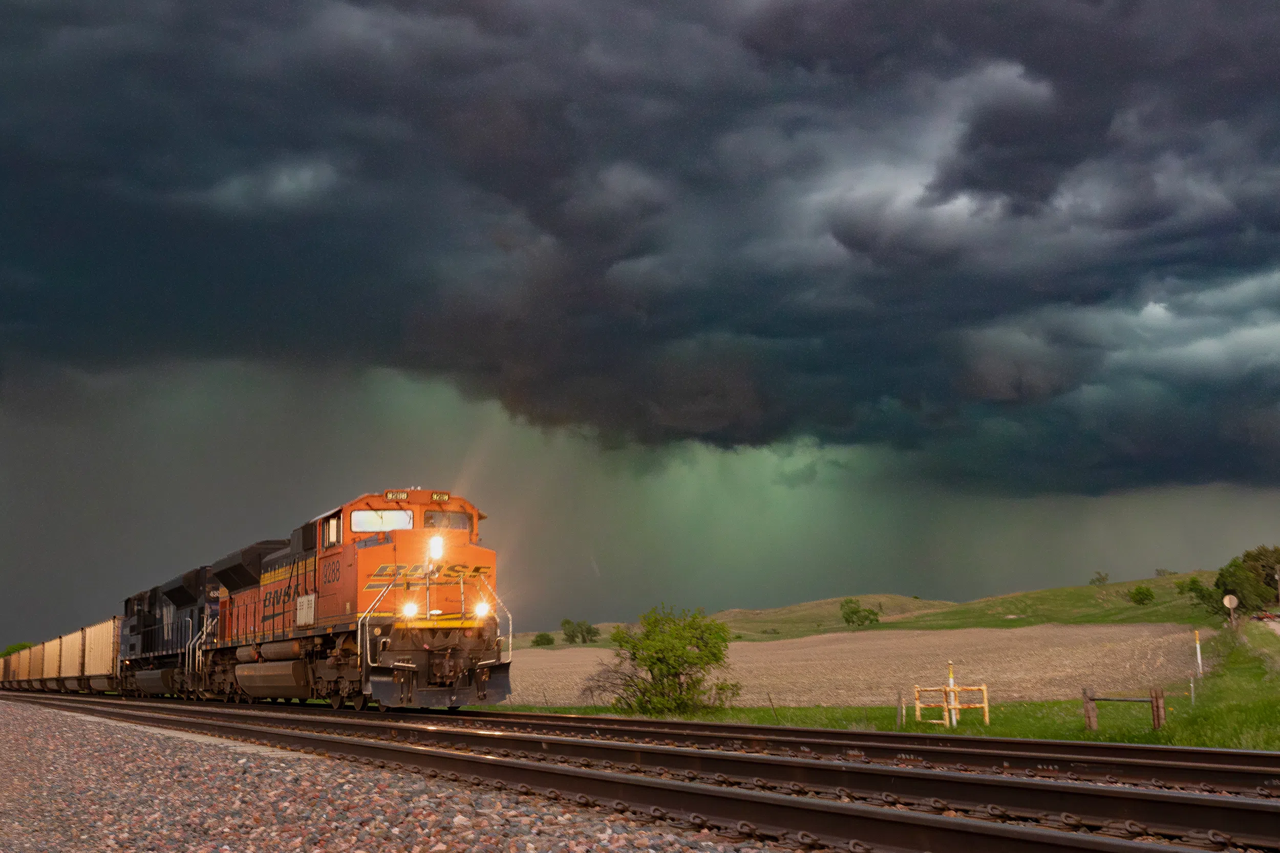
I made my way to the southeast and stopped near the train tracks outside of Berwyn. As the green of the precipitation core hovered on the horizon, a Burlington Northern Santa Fe locomotive was rolling down the tracks.
I dropped to one knee as the BNSF train approached, making sure I wasn’t going to miss my opportunity for this kind of picture. The picture I took of the train rolling down the tracks with the storm dominating the background was one of my favorites of the evening.
With coal cars blocking my view of the immediate horizon as the train passed, I decided to move farther away from the storm to get a wider view of the structure. I drove through Ansley and parked myself on a hill just to the immediate south of town.
I couldn’t help but think the view was something out of a poem about the Great Plains, this small village nestled among the hills as a storm approaches.
Something I did notice was the lack of progress the storm was making on my position. I thought I would only have a few minutes, but I must have recorded around 15 minutes of video from that hill.
I would later learn from the National Weather Service – North Platte that the low-level jet that was strengthening from the south in the evening was overcoming the slow southward movement of the cold front.
Briefly, the low-level jet is a narrow band of strong winds in the lower part of the atmosphere that is a common feature in the Great Plains during the warm season. It is created by a pressure differential that is caused by higher terrain to the west cooling faster than the lower terrain to the west.
Eventually, it was clear that the edge that a segment of the line of storms was starting to make progress on my position and I headed south along Highway 183 to avoid being cut off.
However, I had to briefly stop at the edge of the field between two hills, the sight to the west was just too much to pass up. A looming shelf cloud was rapidly advancing on my location with the cool blue of the precipitation core lagging just behind it.
I held my position as long as I dared and was overtaken by the shelf cloud, revealing the roiling texture underneath the leading clouds. When the stronger outflow winds began to hit my position, that’s when I made the decision to keep heading south.
Rain was beginning to fall as I put the car in drive. This wasn’t the same as racing a supercell’s rear flank downdraft but all the same I didn’t want to get enveloped in the worst of the rain.
When I finally had put enough distance between the storm, I stopped near a larger hill that I wanted to climb up to get a better vantage point. It was a good thing I couldn’t climb as fast as I wanted to because I nearly planted a foot in a patch of cactus that was hidden by the green grass.
The local fauna of Nebraska never ceases to surprise me.
By this point I had felt like I had gotten my fill and with the light starting to fade, I made the decision to get home and await the storm as it approached the Highway 30 corridor.
I had thought about getting some shots in the dark of the lightning lit up the storm, but interestingly, storms that fired along the dryline to the south were coming north and collided with the cold front storms right along Highway 30.
The storm complex would move into the Kearney area around 10:20 p.m. and 66 mph winds would knock down large and small tree limbs across the community.
In all, I was glad to be able to get out and document storms in the local area. I am still on the hunt for a supercellular tornado and have had good luck in June so we will see what the rest of this month will bring.
Summer will be here before I know it.
Editor’s Note: My name is Brian Neben and this is my seventh year as storm spotter and chaser. I write a personal column about each outing, as it helps to collect my thoughts and I have felt like people enjoy reading about my success or failures pursuing this rather niche hobby.