GOODLAND, KAN. — I’ve always had mixed feelings about targeting the dryline in Kansas. You get burned once on a hot stove and it’s hard to try and touch it again.
But that is exactly what was being presented to me on Thursday, April 25.
I hadn’t had a major chase since late March when I drove to within 30 minutes of the Oklahoma border for gas, storms never fired in the dry environment like I hoped they might.
However, Thursday stood out as a chase date nearly a week prior, a longwave trough of low pressure was set to eject out into the Plains with an area of surface low pressure developing in eastern Colorado. A dryline was set to develop and a warm front would be lifting north across northwestern Kansas.
The reason I am nervous about targeting the dryline in western Kansas goes back to May 26, 2021. I was certain that on that date we could get several supercell thunderstorms firing off the dryline and remaining discrete as they put on a tornado show.
When the Storm Prediction Center uses the words “particularly dangerous situation,” in their wording, you tend to get excited if you are a weather enthusiast.
But there is a catch with the dryline, the forcing for storms can be so subtle it might not overcome other environmental factors, such as the cap, a term used in the weather community to describe a layer of warmer air above the ground that inhibits thunderstorm development throughout most of the day.
If the cap is too strong, storms may not fire at all, resulting in a blue sky bust, or storms may fire but then struggle to breach the warmer air.
That is exactly what happened on May 26, storms fired but quickly choked and died, the cap – too warm that day – never giving them a chance. This is the worst bust I have endured so far, likely because my expectations had been set so high.
So when Thursday, April 25 looks to feature storm’s firing off the dryline in western Kansas and a 10 percent chance of tornadoes, some of which could be strong, I always have some mental reservation in my head.
The day of the event, National Weather Service offices in the area felt there was a good chance storms would form but there were other factors to consider. The warm front was expected to lift only so far north, so storms may fire but they would only have a short window in the warm sector and the greater wind shear was expected to ramp up in the evening around 6-7 p.m.
I did have to factor in that Thursday looked to be the first day of at least four severe weather episodes across the Plains and Midwest, as two troughs looked to eject into the area, back-to-back.
With the idea that the storm chances on Saturday seemed even better, I decided I could stand taking the risk on the dryline on Thursday with the thought that I would have other chances soon after.
I made the decision to target Oakley, Kan., and arrived in the community around 2:30 p.m. Other chasers were already waiting on the edge of town. We could see the cumulus field to our southwest and this marked the edge of the boundary we expected storms to form on.
Around 3 p.m., the first storm of the day began to initiate along the Colorado-Kansas border along the Interstate 70 corridor. I didn’t waste any time headed west toward Goodland, Kan., preparing to cut the storm off as it passed north of town.
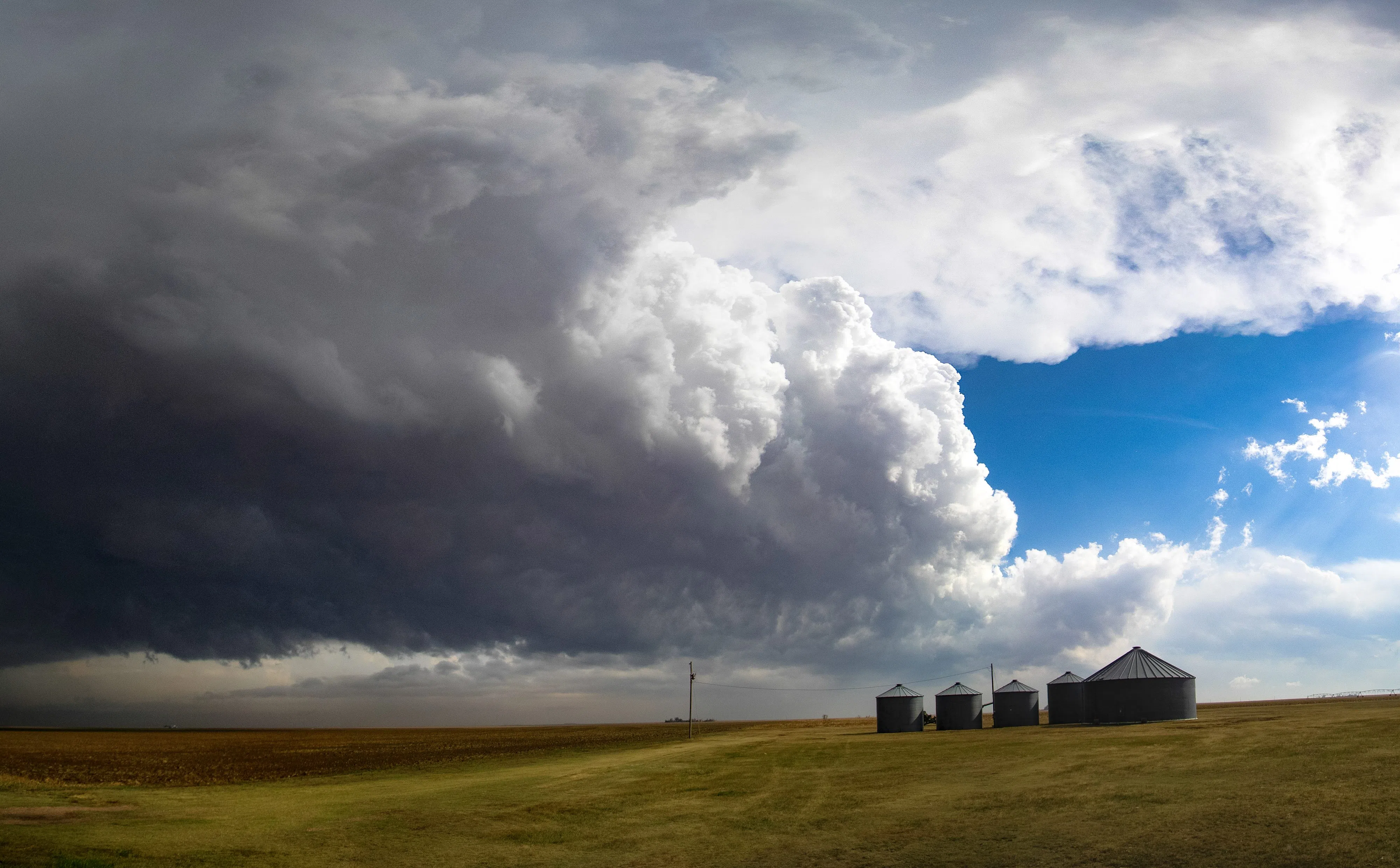
On radar I could tell several updrafts had formed and they seemed to be in the process of merging together to form one larger storm. By the time I had gotten north of Goodland, I could see some of the structure I look for in a storm, the updraft base and precipitation core falling to its northeast.
I was able to keep in close proximity to the strengthening storm thanks to Highway 27. By now the storm was starting to form some wall clouds and I could tell a few rear flank downdraft bursts had occurred.
It was still early in the storm’s life but it was encouraging to see the supercell processes starting to take shape.
I kept jogging north with the storm, but there was a slight issue, the cell was oriented east of the highway and the backside of the storm was masking the inflow area that I usually try to target by being on the southwest side of the storm.
Why not take the gravel roads of the rural road grid to get on the other side?
That question was answered for the public when I pulled alongside a storm chasing tour group. Your average citizen can sign up for one of these tours and they will take you on a week-long trip, trying to put you in the best position to witness severe weather, with a tornado sighting as the highest goal.
One of the women in the group asked the tour guide why more chasers were not using the gravel roads around the storm.
The guide’s response made me laugh, he turned to her and said, “Storm chasers aren’t that stupid.”
He was alluding to the fact that gravel roads around storms can become great places to get our car stuck when it has been raining and I’ve found the backroads of western Kansas are particularly notorious for turning into a clay soup in a heavy rain.
I also enjoyed his insinuation that most chasers have to be just a little nuts to partake in this hobby.
While I was near the tour group, I saw what was likely the storm’s best chance at producing a tornado, in fact it did, but I was on the backside of the storm and unable to get eyes on it.
However, the tornado in question was a narrow needle of a funnel that was hardly worth writing home about.
I continued north and began heading east for Bird City, Kan., which had been in the path of the tornado warned storm. To the east of town, I saw what was likely one of the last attempts to form a wall cloud, which turned out to be meager at best.
Once you’ve been chasing for half a decade, you tend to get a sense for which storms could produce a tornado and which are just not tapping into the right ingredients.
Unfortunately, the storm began to move off north of the warm front and away from the better moisture and lost its tornado warning.
I sat in Bird City for a moment to consider my options. There were additional storms firing to my south off the dryline, but the convection was spaced so close together I could tell a general line was going to form.
I could attempt to follow my earlier cell as it crossed into Nebraska but there was a novel issue running into on the east side of Bird City – fog.
The cool outflow from the storms in the area may have suppressed the temperature closer to the dewpoint, causing the moisture in the air to condense. The fog would prohibit me from getting eyes on tell-tale storm structure I use to gauge storm strength and now to navigate.
But heading farther east out of Bird City I felt more like I was in Scotland than Kansas.
With the visibility issues in mind and the fact I could be swallowed up by a developing line of thunderstorms I made the decision to call the chase and count on the coming days for better chasing opportunities.
That left getting out of Kansas without being enveloped in a wall of rain curtains and hail. I have been struck trying to get home by punching through a line of storms and the experience leaves something to be desired.
Luckily I was able to stick on the highway and shoot the gap between storms, finally getting out of the dense fog around Norton, Kan.
I was able to get far enough east and the storms were heading northeast enough that I wouldn’t run into them until I was close to home. However, I could tell on the way that much of central Nebraska was under a deluge of rain, which is something we have sorely been in need of.
The only time I was truly getting rained on was when I neared Holdrege and could see the considerable amount of lightning that was being generated as the light faded. I finally arrived at home just as the heavier rain was setting in.
My thoughts on this Thursday chase are mixed. On one hand, I got to see my first supercell structure of the year and it is a confidence boost to navigate safely near a tornado warned storm.
On the other hand, I had a bit higher hopes for this setup, but I have found that the devil is in the details when it comes to observing the weather. A boundary further north, cooler temperatures than expected, it all can have an outsized impact.
If I was looking at this day in a vacuum I might not think much of it, but what occurred on the following day, Friday, April 26, I could not have anticipated…
Editor’s Note: My name is Brian Neben and this is my sixth year as storm spotter and chaser. I write a personal column about each outing, as it helps to collect my thoughts and I have felt like people enjoy reading about my success or failures perusing this rather niche hobby.